Author: Sharon and Angus MacInnes
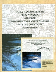
Combo: Book + CD. This atlas brings to light one of the most invaluable new tools for researchers of western Pennsylvania: Township Warrantee Maps of the tracts which the Penn family, and then the Commonwealth of Pennsylvania, sold to the first settlers of Fayette County. Starting in 1907, the Commonwealth of Pennsylvania commissioned draftsmen to draw connected maps from the original deeds of the earliest purchasers of tracts; they completed about 1/3 of PA counties before the project came to an end. This treasure trove of maps is housed in the Pennsylvania Archives in Harrisburg and is now being brought to researchers in this Early Landowners of Pennsylvania series.
The tract maps show the outlines of the metes and bounds of the original tracts sold by the Penn family, and later by the Commonwealth of Pennsylvania, to the first settlers of Fayette County; names of the warrantee and patentee; name of the tract; dates of the warrant, survey, and patent; and the patent book and page number where the tract is registered.
Each chapter contains the map of the township showing its tracts (reduced to 8.5 X 11" size), followed by a chart containing all data on each tract in alphabetical order by the name of the warrantee. The chart also shows the coordinates where the tract will be found on the township map preceding the chapter. Numerous footnotes from a variety of sources document further information on pioneers and some successive owners, as well as family relationships in some cases. [A slightly different version of these Township Warrantee Maps was published in the third volume of the Horn papers which has long been out-of-print.]
In addition to documenting the first landowners of Fayette County, the atlas can often reveal family relationships or clues to possible relationships since relatives usually congregated near one another. Secondly, since people usually moved in groups, tracking sets of families and neighbors as a whole can frequently suggest routes of migration. Finally, later owners of these tracts can be traced back to the exact location of their plat by following their transactions through deed and will books. In some cases, names on the Township Warrantee Maps are the only record that certain people actually existed.
This atlas of Fayette County is the third volume in a series that will eventually cover all of the counties for which Township Warrantee Maps exist. Index. The larger images (averaging about 3' X 4') without coordinates are contained on a companion CD and is included in this package.
2005, 8.5" X 11", Softbound, 406 pages
ISBN 1558564305 (Book + CD) BEST BUY
Price: $45.00
SKU: COMBO-518
Usually ships within1-3 days